In this section you can buy visual
rail transit books published by the CityRailTransit´s
webmaster. Focused at underrepresented rail
transit systems, main goal of these books is to
offer a pictures collection of the overall rail
transit stations within a city´s metro area.
Thus, every single station is, usually, pictured
twice. Concerning to (mainly) light rail/tramway
systems, sections between two consecutive
stations are also pictured in order to show its
layout (i.e. private right of way, streetcar
service, reserved platform, level crossings,
etc.). Also, maps of current rail transit network
and future projects as well as layout of the
lines are included.
HOW
TO ORDER: by clicking over the correct PayPal Buy Now!
button: select your area (EUROPE and REST
OF THE WORLD)
(delivery time: usually within the next 10-15
days after payment) |
|
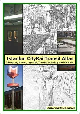
Istanbul
CityRailTransit Atlas
Subway,
Light Metro, Light Rail, Tramway & Underground
Funicular
by Javier
Martínez Cuevas
Text: ENGLISH
Paperback (14.4 x 21.0 cm)
124 pages
168 color pictures
4 to-scale network maps
Lay out of the lines
|
Although an
abundant English literature about the history of the
public transportation in big western cities (London, New
York City or Paris) is available, the Internet seems the
better (also, the faster) way to access to information
about transit networks all over the world. Nevertheless,
English-related information about eastern cities´
transportation networks like Yerevan, Tianjin or Istanbul
(among others) is rarely available (neither books nor web
sites).
This lack of available information about Istanbul´s public transportation (as well as the idiomatic barrier that supposes the Turkish language for English-speakers that prevents access to Turkish-related information for the transit aficionado) implies that, still today, Istanbul´s public transportation network reminds as one of the most mysterious networks for mass rapid transit fan´s eyes. As an example we can consider the entirely segregated (without level crossings) light metro system (Hafif Metro) which is frequently considered as a light rail system.
On the other hand,
the variety of rail-based types of transportation,
converts Istanbul in a little paradise for the transit
aficionado: tramways, light rail, light metro, subway,
funiculars, etc. both all are included in its rail
transit network. They compose a complex network that,
unfortunately, cannot cover the transportation needs of a
city which population reaches ten million inhabitants.
Main aim of this
book is to offer an overview of public transportation´s
history in Istanbul from its beginnings in the XIX
century up to the present days, as well as bring a
pictures´ collection of its current network in order to
provide accurate visual information for the reader.
CONTENTS
Brief History of the City - page 1
The Beginnings of Istanbul´s Public Transport -
page 4
Horse-driven Tramways - page 7
The Underground Funicular - page 9
Electric Tramways - page 13
Road Traffic - page 18
Sea Transportation - page 22
Suburban Trains - page 24
Light Metro - page 27
Light Rail - page 58
Subway - page 96
Future Network - page 109
|
INDEX OF
PICTURES
|
|
Toulouse
CityRailTransit Atlas (ISBN
84-689-2673-6, published on November 1, 2005)
|
Toulouse CityRailTransit
Atlas
Métro Line A & Line C
by Javier Martínez Cuevas
Text: ENGLISH
Paperback (14.4 x 21.0 cm)
73 pages
93 color pictures
4 to-scale network maps
Lay out of the lines
|
Toulouse
metropolitan area with over 1 million inhabitants
is the fifth largest metropolitan area in France.
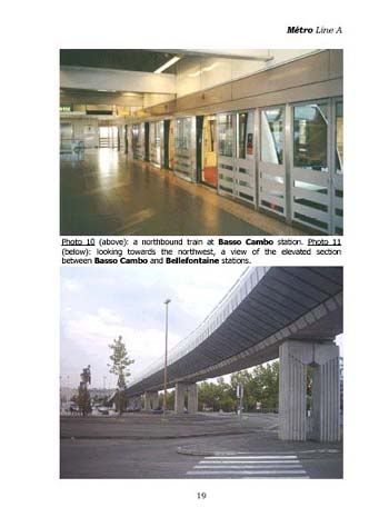
Since 1993 its first subway links downtown to
Basso Cambo towards the southwest, and
Balma-Gramont towards the northeast (opened in
2004).
Designed as
a fully automated VAL system, Métro Line A
(first subway line) became immediately very
popular and well used and, also, recorded traffic
soon exceeded the most optimistic forecasts. The
increasing demand of transportation due to a
population growth of 1.5% within its metropolitan
area caused the beginning of the construction of
the second subway line (Métro Line B), scheduled
for 2006.
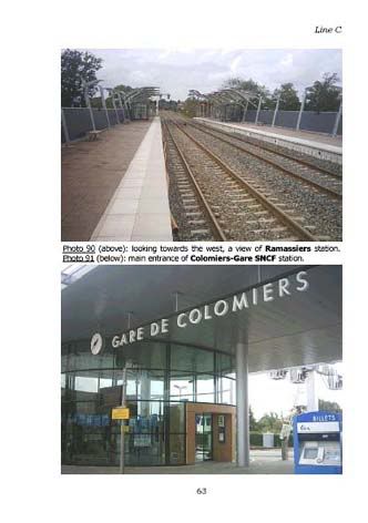
Complementing
the subway network, the Transportation Master
Plan approved in 2001 contemplates the creation
(among others) of a suburban trains´ network
which first line is current Line C.
Main aim of
this book is to bring a pictures´ collection of
every single station included within Toulouse´s
current rail transit network in order to offer
accurate visual information to the transit
aficionado.
CONTENTS
Brief History of the City - page 1
French National Railways - page 4
T.E.R. - page 7
Tramways - page 12
Métro Line A - page 14
Line C - page 56
Future Network - page 65
|
INDEX OF PICTURES
|
|
Rome
CityRailTransit Atlas (ISBN
84-690-0406-9, published on August 17, 2006)
|
Rome CityRailTransit Atlas
Metro A & Metro B
by Javier Martínez Cuevas
Text: ENGLISH
Paperback (14.4 x 21.0 cm)
107 pages
134 color pictures
2 to-scale network maps
Lay out of the lines
|
Rome
is one of the most visited cities in the world
but, still today, its metro network remains as
one of the most underepresented rail transit
system within English-related literature.
Nevertheless, several Italian books concerning to
this topic have been published in the past
although they are frequently out of print.
Images, as well, concerning to this rail transit
network are rarely available in the net and
articles about history are, in most cases, not
accurate.
In such
scenario, the author chose the metro network of
Rome as the case study of the third visual book
of the CityRailTransit publications. In this book
you will find a photo collection which includes,
mainly, every single metro station currently in
operation within Rome´s metro network as well as
an overview of the history of Rome´s rail
transit network. Last but not least, a brief
chapter is dedicated to the future rail transit
network in which future projects are described.
Main aim of
this book is to offer an overview of the history
of the Rome´s metro network from its beginnings
up to the present days, as well as to bring a
pictures collection of its current network in
order to provide accurate visual information to
the transit aficionado.
CONTENTS
Overview - page 5
Tramways - page 9
National Railways - page 12
The Roma-Nord railway - page 17
The Roma-Pantano railway - page 21
The Roma-Lido railway - page 25
Metro B - page 29
Metro A - page 64
Future Network - page 101
|
INDEX OF
PICTURES
|
|
Home Page
This page was
modified on August 7, 2012
|